Expanding What’s Possible: Advanced Scanning Capabilities
With SSR’s recent acquisition of GFY, our clients now have access to a powerful new set of scanning capabilities—technology that fundamentally changes how existing conditions are documented, analyzed, and used across the built environment.
From buildings and campuses to utilities, infrastructure, and large outdoor environments, GFY’s scanning expertise enhances our ability to deliver more accurate data, greater efficiency, and deeper insight, often in significantly less time than traditional methods.
What Is Scanning and Why It Matters
At its core, scanning creates a highly detailed digital record of real-world environments. Using survey-grade equipment, millions of data points are collected and assembled into 3D point clouds that can be measured, analyzed, and modeled long after fieldwork is complete.
The result is a digital representation of a space or site that allows teams to revisit conditions virtually, reduce return site visits, and make better-informed decisions earlier in the process.
A Flexible Toolkit for Nearly Any Environment
Our new scanning capabilities span multiple technologies, allowing SSR to match the right approach to each project’s needs.
Terrestrial (Tripod-Based) Scanning
These stationary scanners are ideal for projects that demand high accuracy and long-range visibility. Strategically placed throughout a site, they capture everything visible within line of sight—structures, terrain, utilities, and architectural details.
This approach has been used for applications ranging from structural assessments to complex building measurements and post-event documentation, such as capturing detailed conditions following storm damage or construction incidents.
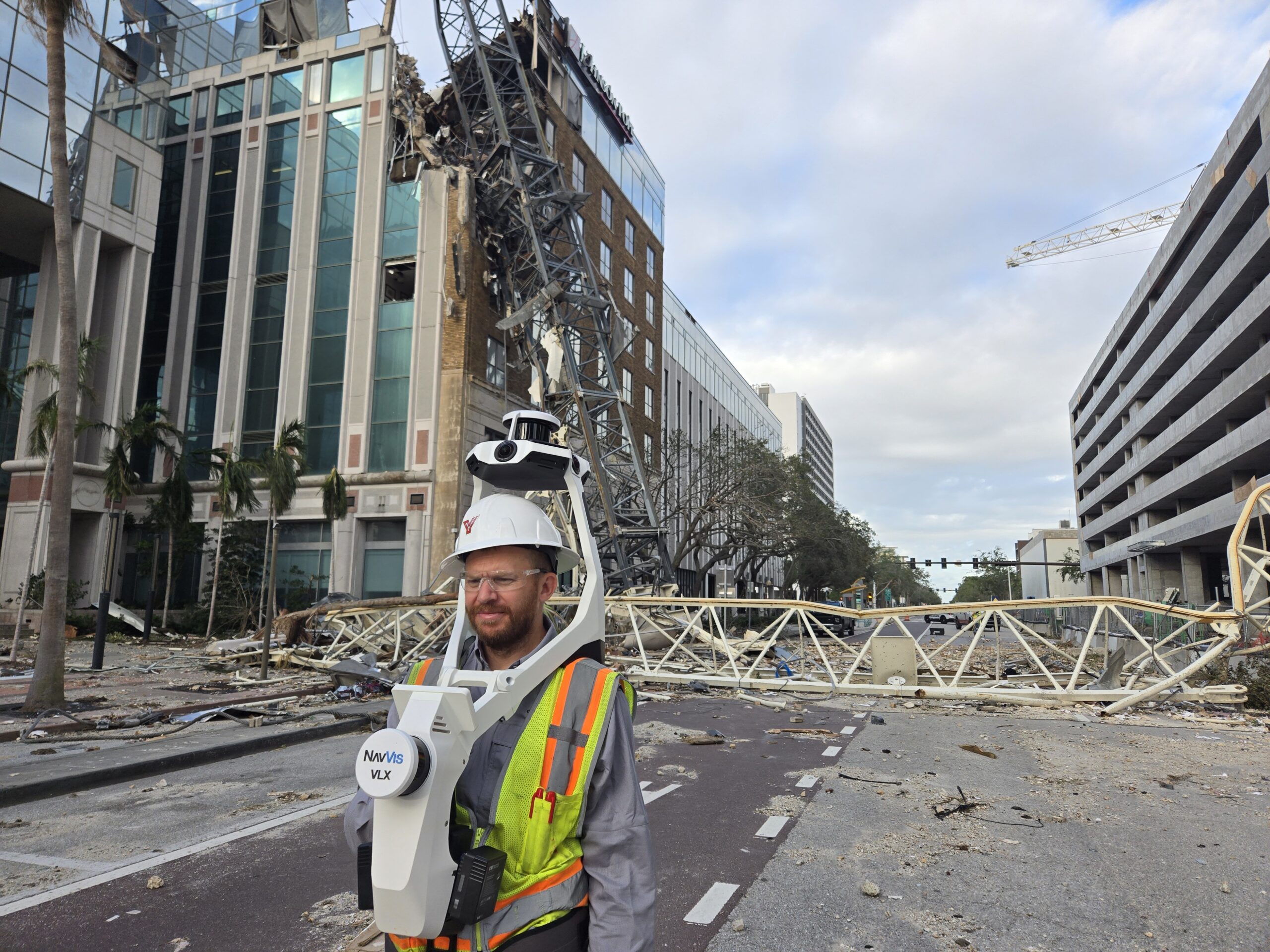
Mobile Wearable Scanning
One of the most versatile tools now available to clients is mobile wearable scanning technology, which allows teams to capture highly detailed spatial data simply by walking a site. This technology has applications indoors and out, and is ideal in environments where speed, safety, and completeness of data are critical.
Inside Buildings: Fast, Non-Disruptive Capture
Indoors, the wearable scanner excels at capturing complex, occupied spaces with minimal impact to daily operations. A technician walks through a facility at a normal pace while the system collects millions of data points per second, along with integrated panoramic photography.
Entire building interiors—offices, mechanical spaces, corridors, and even above-ceiling utilities—can be captured in a matter of minutes. The resulting data allows teams to:
- Measure any element within the space long after the site visit
- Locate utilities, fire protection systems, and life-safety components
- Support renovation planning, equipment inventories, and system upgrades
- Reduce or eliminate repeat site visits
This approach is especially valuable in healthcare, education, and secure facilities where access can be limited or disruptive.
Outdoors: Capturing What’s Hard to Measure
The same wearable scanning technology is just as powerful in outdoor environments, particularly in places where tripod setups or traditional surveying methods are slow, obstructive, or unsafe.
Because the system is mobile and guided by real-time feedback, teams can efficiently scan large, complex outdoor areas such as:
- Utility substations and industrial sites
- Dense structural environments with overhead components
- Campuses, plazas, and tight exterior corridors
- Construction sites and post-incident locations
In these settings, crews can be on site for as little as an hour and walk away with enough data to digitally recreate every visible feature—from poles and equipment to grade changes and overhead lines.
Drone and Mobile LiDAR Capabilities
In addition to ground-based solutions, enhanced aerial and mobile scanning capabilities are now available to clients.
Drone LiDAR and photogrammetry support large-area topographic surveys, beach and shoreline monitoring, tree inventories, and development planning.
Mobile vehicle-mounted LiDAR allows data collection along highways, corridors, airport runways, and large pavements—often at roadway speeds—improving safety by eliminating the need for crews in active traffic.
These technologies can also support asset management and pavement condition assessments, producing detailed, georeferenced data that informs maintenance and capital planning.
Turning Data Into Actionable Insight
Scanning isn’t just about creating impressive visuals—it’s about what clients can do with the data.
Structural and Engineering Analysis
Scans can reveal structural systems hidden behind finishes, allowing engineers to identify deficiencies, trace load paths, and design targeted repairs or reinforcements without invasive investigation.
Digital Twins and Future Planning
Scanning provides the foundational data needed to create digital twins—virtual replicas that support renovation planning, system upgrades, and scenario testing. In facilities like hospitals, this means teams can locate fire protection systems, life safety devices, and equipment inventories without stepping back on site.
Utility and Industrial Applications
For substations, treatment plants, and industrial facilities, scanning captures complex networks of pipes, conduits, and equipment. This data can be fed directly into CAD or design software, creating accurate as-built models and reducing unknowns during future work.
Large-Site and Infrastructure Surveys
In one example, a large multi-building site slated for demolition was fully captured in just days—work that traditionally would have taken weeks. The data supported permitting, quantity calculations, and future grading plans while saving both time and cost.
Post-Incident and Forensic Documentation
In cases such as construction accidents or storm damage, any combination of our scanning equipment can be deployed quickly to capture conditions exactly as they exist—often in under 30 minutes.
This gives owners, engineers, and insurers a permanent, measurable record of:
- Impact locations and extents
- Structural damage and debris fields
- Relationships between surrounding buildings, roads, and infrastructure
Because everything is geo-referenced, the data can be revisited and analyzed long after the site has changed, supporting investigations, insurance claims, and engineering evaluations.
Expert Teams, Seamless Integration
Technology alone isn’t the differentiator—the expertise behind it is. Our team brings years of experience in surveying, scanning, and data interpretation, ensuring that the information collected is accurate, usable, and aligned with each project’s goals. Equally important, these capabilities integrate seamlessly with SSR’s existing engineering, planning, and consulting services.
The result is a more collaborative, efficient approach, one where teams have the right data at the right time and can spend less effort collecting information and more time solving problems.
Looking Ahead
With scanning now part of SSR’s expanded service offering, clients gain access to tools that reduce risk, improve accuracy, and unlock new possibilities across markets and project types.
In many ways, reality capture changes the question from “Did we collect enough data?” to “How else can this data work for us?” and that shift opens the door to smarter decisions and better outcomes.